
Drop the top, roll down the windows, and head out on the highway. Whether it’s a little red Corvette or a wood-paneled station wagon (or a compact rental car like the one I picked up in Kansas City, Missouri), your vehicle will take you on a fascinating journey on just about the most famous and influential road in the United States: Route 66. Sure, the Going-to-the-Sun Road in Glacier National Park and the Overseas Highway in the Florida Keys may be among the most beautiful drives in the world, and State Route 1 along the California coast may be more exhilarating, but Route 66 will rev your engine of curiosity, history, quirkiness, and nostalgia (for those of a certain age) like no other road in the country.
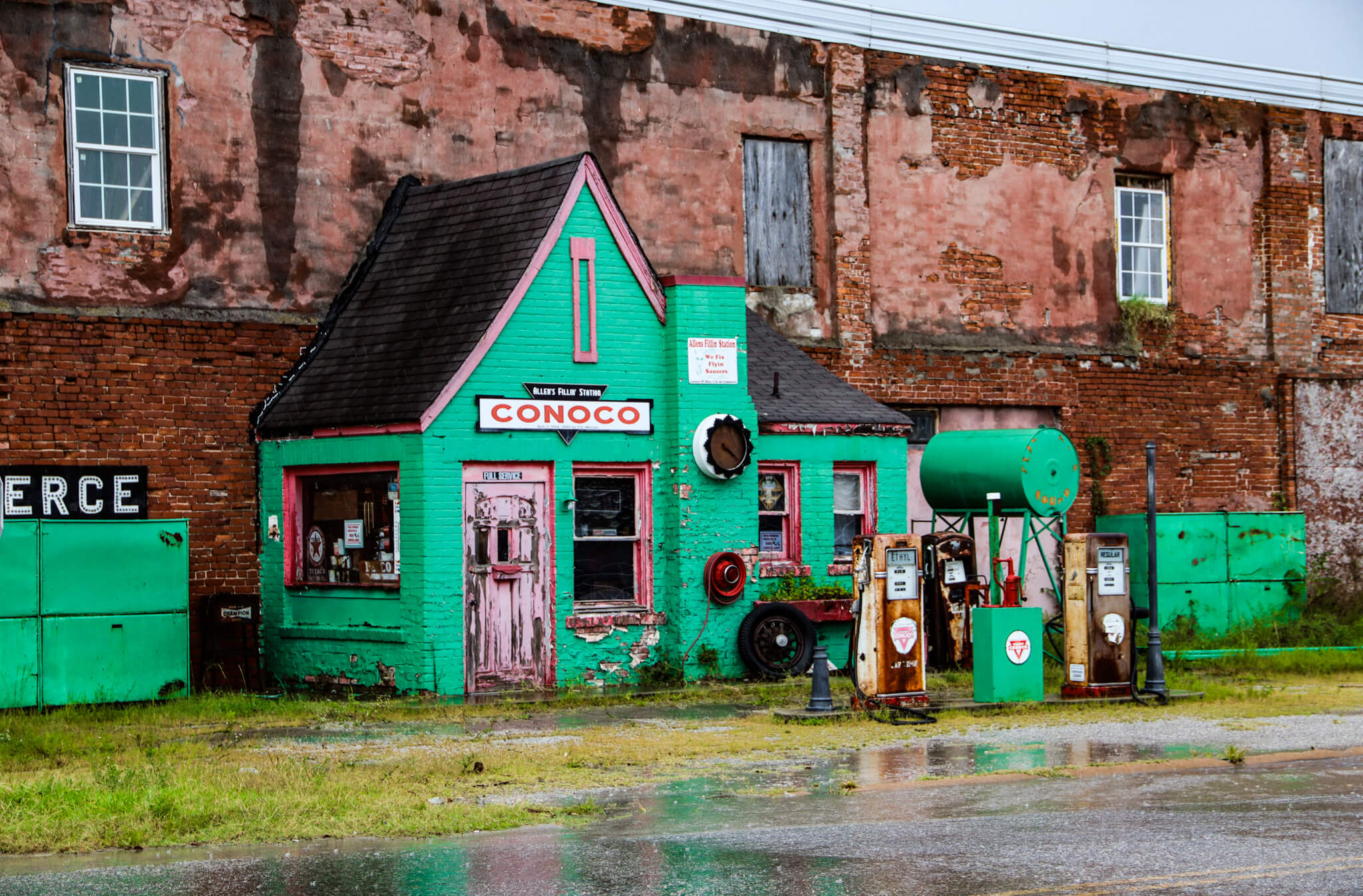
Allen’s Conoco Fillin’ Station started filling tanks nearly a century ago.
Many years ago, I touched on Route 66 for a bit in New Mexico—my first experience with this deservedly famous thoroughfare. When I had the opportunity to do it again with a little more planning, this time in Oklahoma, I instinctively ditched the interstate and major roads and cruised onto this indelible strip of Americana through the Sooner State. Crossing into the northeastern corner of Oklahoma from Kansas (which got the short end of the route’s plan, with only 13 miles) and heading toward my final destination, I would pass through both large cities and tiny, often forgotten towns where Ace Hardware is listed as a shopping destination and Cracker Barrel is recommended as a good place to eat.
Starting in Chicago and ending in Santa Monica, California, the 2,448-mile highway ran through eight states and three time zones. Conceived of by Cyrus Avery, a businessman from Tulsa, Oklahoma, US 66 functioned primarily as a route for migrants heading west, particularly during the Dust Bowl in the 1930s. John Steinbeck, in his novel The Grapes of Wrath, describes the highway and nicknamed it “The Mother Road.” Also known as “The Main Street of America” and “The Will Rogers Highway,” Route 66 often ran down the principal street of countless towns, stimulating economic development and prosperity as car ownership boomed. Travel by automobile soon spurred related business—accommodations, diners, auto repair shops, gas stations, drive-ins, and tourist attractions. People who ran businesses along the route soon began to reap the profits of their fortuitous location. But when President Eisenhower introduced the Interstate Highway System to create a desperately needed component of a national defense system, these same businesspeople saw that the brakes were about to be slammed on their success. Although they tried to save Route 66 and its vital importance to them, it was officially removed from the United States Highway System in 1985 after a long decline precipitated by the new interstates luring drivers onto their quicker and more direct routes across the country. Largely abandoned and left to decay for years, “Historic Route 66” has now made a striking comeback, and there’s no better time than right now to hit the road already.
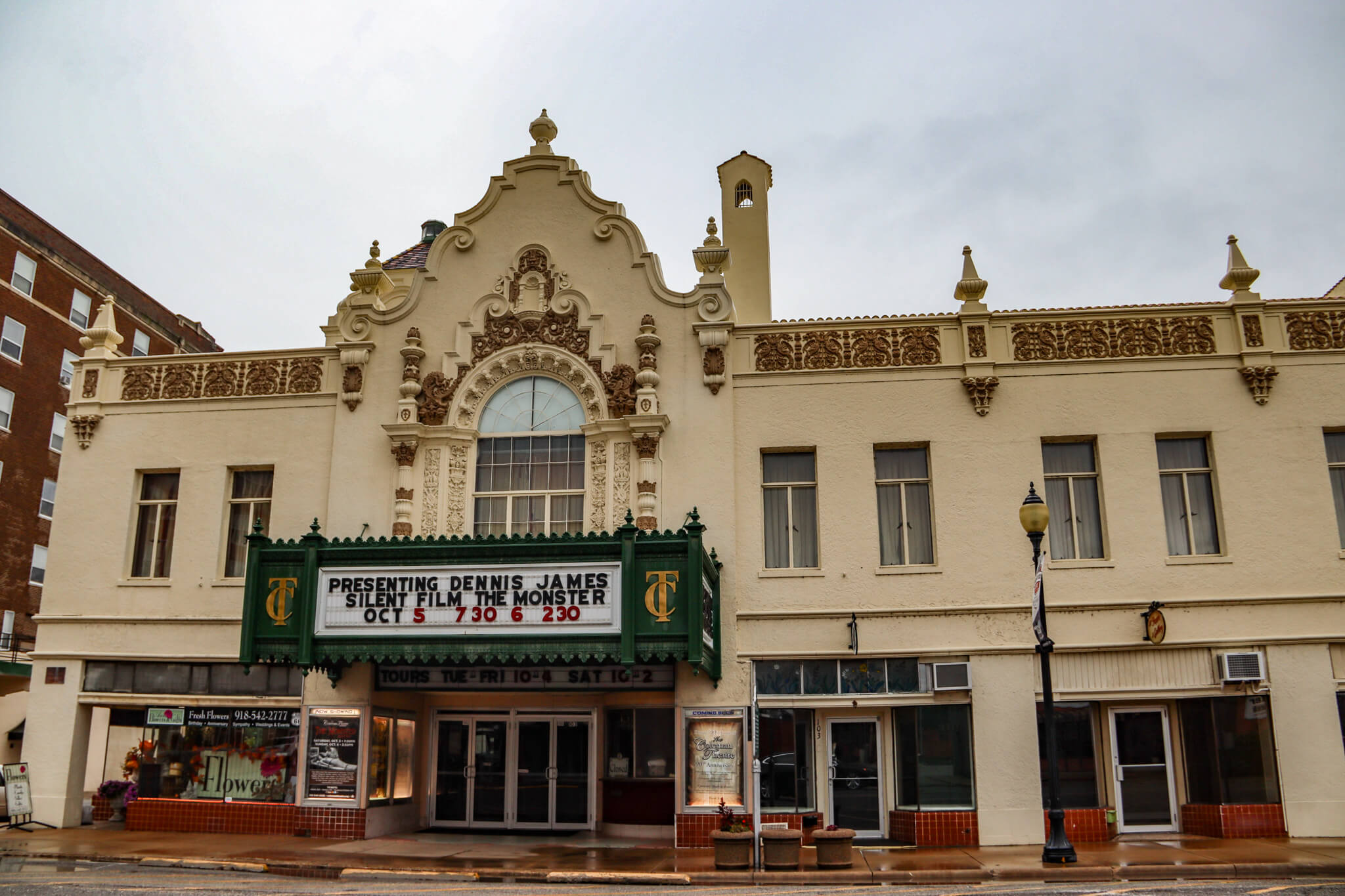
Coleman Theatre add a splash of Spain to Miami, Oklahoma.
With more than 400 drivable miles, Oklahoma claims the lion’s share of Route 66. I made my first stop in tiny Commerce, with a population that has never exceeded 2,700. Originally part of an Indian agency and then a mining town that warranted a rail line, the creation of nearby Interstate 44 and the ensuing closure of the mines left Commerce a catatonic backwater. Although a few cars were parked along the main street, nobody was up and about. Known for nothing except as the one-time home of Mickey Mantle and the scene of a Bonnie and Clyde shooting and kidnapping one month before they were killed, Commerce beckoned me with two survivors of Route 66’s golden age. Allen’s Conoco Fillin’ Station, built out from a brick wall of the last building on the town’s main street in 1929, is now a gift shop and mini-museum, with its rusting gasoline pumps—one regular, one ethyl—and flaking green and pink paint recently restored. Across the street, a neon-fringed, doll-house–style former gas station is now a Dairy King that is the only place in the world where you can purchase cookies shaped like the Route 66 shield.
Properly introduced to what Route 66 is, and was, as well as to its unique quirkiness, I headed south for five miles and stopped in Miami to see the town’s best attraction. In 1929, a population of eight thousand seemed big enough to warrant the construction of the Coleman Theatre. This Spanish Mission Revival–style 1,600-seat theater, with an unexpectedly striking Louis XV interior, began its life as a vaudeville venue before switching to a movie house. The theater has never gone dark, and over the years, it has attracted such performers as Will Rogers, Tom Mix, Bing Crosby, and Jim Thorpe. Today it hosts ballets, operas, jazz bands, country and western acts, and film screenings, including silent moves accompanied by music and sounds produced by a Wurlitzer organ—the only Wurlitzer organ built in 1928 that is still in its original home.
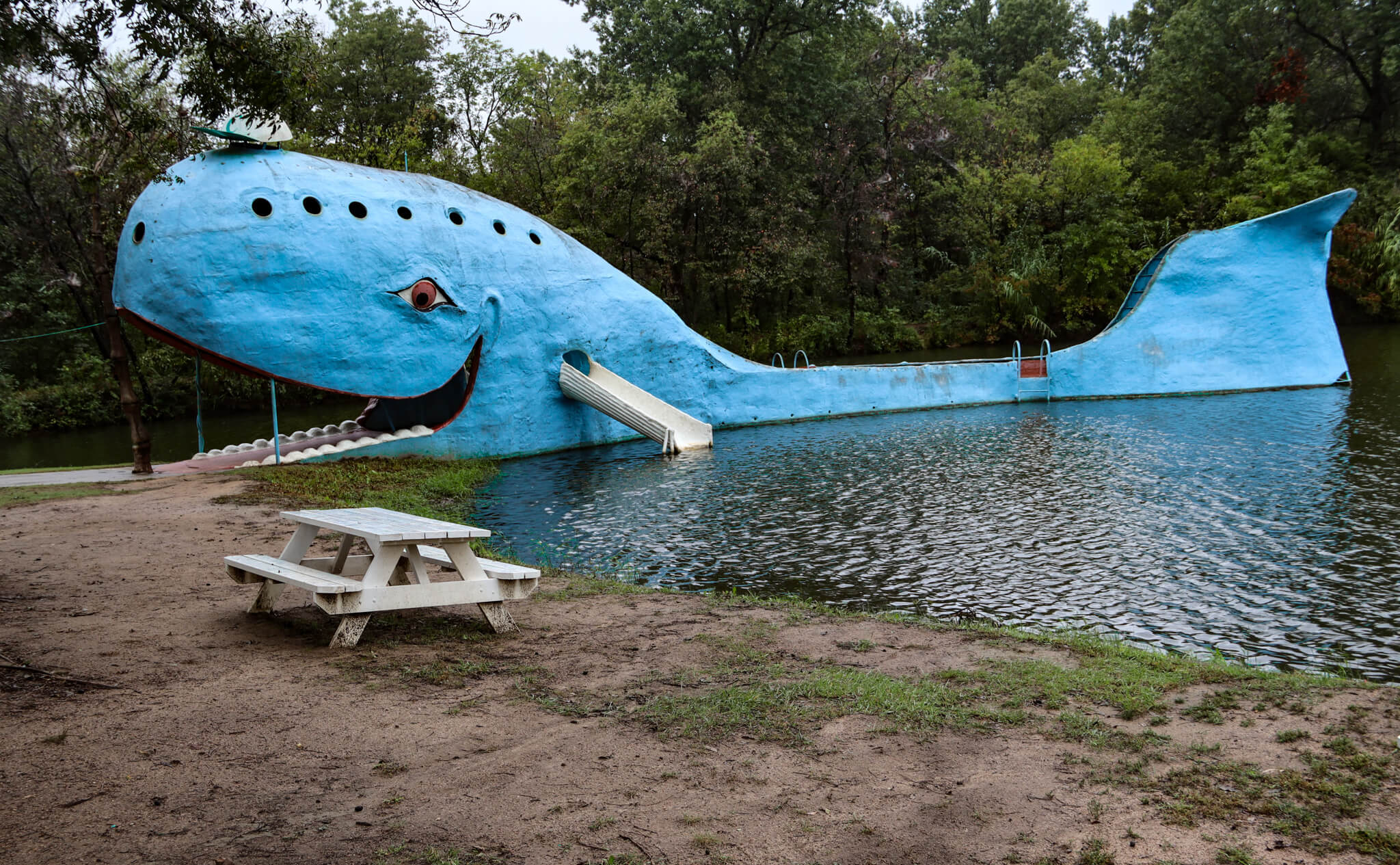
The Blue Whale found a home in Catoosa, more than 1,000 miles from any ocean.
Over the next hour, I cruised down Route 66 in a southwesterly direction through the small city of Vinita, the unincorporated community of White Oak, the small towns of Chelsea and Foyil, and the census-designated places of Bushyhead (named for a Cherokee chief, and a place that hasn’t had a post office since 1955) and Sequoyah. I pulled into Claremore just in time for lunch. With a population that has been increasing every decade since 1910, thanks to its proximity to Tulsa, Claremore houses a museum honoring native son Will Rogers and the handsome Belvidere Mansion, built in 1907 for businessman John Bayless, who died just before his dream house was completed. Today, you can see what Bayless never had the opportunity to experience during a house tour. For my midday meal, I slid into a booth at the bustling Hammett House Restaurant. I was attracted to its history as a family-owned eatery since 1969, its reputation for home cooking, and its “legendary” pies. Alas, quantity trumps quality here, with a big bowl of meh matzoh ball soup, a chicken and vegetable dish accompanied by gluttonous amounts of noodles, and a 7”-high peanut butter–chocolate chip pie. But, then again, I really shouldn’t have expected fine dining in a place that serves lamb testes.
A dozen miles away, I stopped at one of the most offbeat and most iconic attractions at any point on Route 66, in the small city of Catoosa. It’s hard to miss the 20’-tall, 80’-long blue whale just off the side of the road. Floating in a small pond and made of iron and cement, painted blue, and wearing an undersized baseball cap, the Blue Whale has been an oddball curiosity since 1972, when it was born as a husband’s anniversary gift to his wife, who collected whale figurines. It grew into a popular swimming hole for both locals and travelers, who could walk into the mouth of the whale, Jonah-like, and then slide or jump into the water. Although it has been closed since 1988, I was still able to walk around it and laugh at its weirdness.
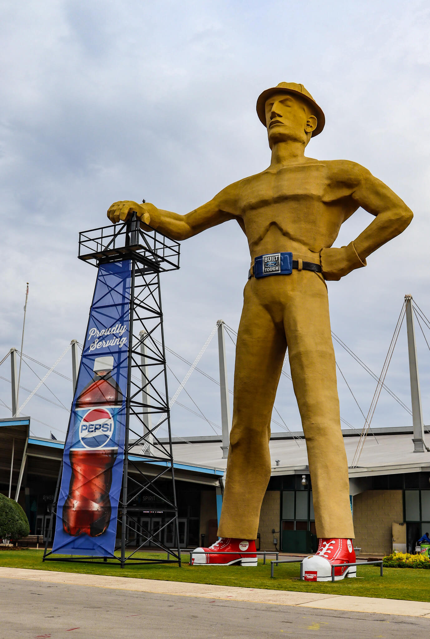
One of the tallest statues in the United States, the Golden Driller keeps an eye on Tulsa.
I finished my first stretch of Route 66 in Tulsa. Oklahoma’s second-largest city owes a huge chunk of its development both to the discovery of oil and to the road, which now runs just south of downtown. The heart of the city seemed to be as deserted as every other place I had stopped at along the way so far, which was rather peculiar, given the large hotels and huge office buildings downtown, along with municipal buildings and the performing arts center, and not to mention the third-largest concentration of Art Deco architecture in the United States, and the terrific Boiler Room restaurant in the lobby of a historic hotel. Although a thoroughly modern city, Tulsa is not without historical reference to the road that help boost it, acknowledged by 29 historical markers along its way through the city. It also boasts another of Route 66’s zany things to see —one of the 10 tallest statues in the United States. The Golden Driller, a colossal statue of an oil driller, stands 75’ tall. Wearing a hard hat and a belt (size: 48′) with a “TULSA” buckle, and painted a golden yellow, he rests a hand atop an oil derrick. In 1979, he became Oklahoma’s state monument.
After a few days here, I was back to getting my kicks on Route 66, pausing briefly in Chandler at the adorably small building that served as a gas station until 1992. Officially, it’s the “Phillips 66 Filling Station No. 1423.” Built in 1930, the small brick building, painted green with red and blue trim and with two circular windows up near the peak of the steeply pitched roof, looks more like a cozy cottage that might be inhabited by mirthful woodland creatures in a fairy tale than a place to fill it up.
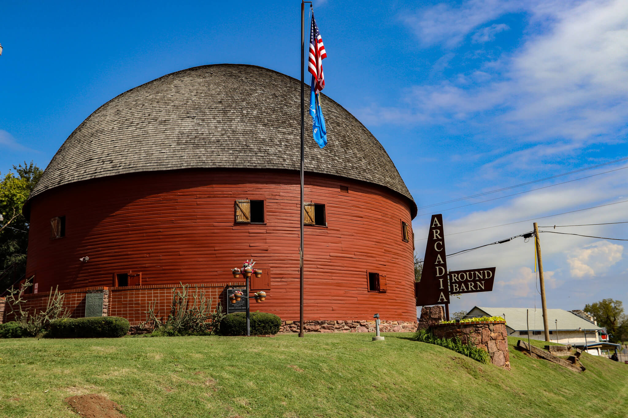
Built to last, the Round Barn has survived hurricanes and the demise of Route 66.
Travelling west, I stopped in the town of Arcadia to see the red Arcadia Round Barn, erected in 1898. The only truly round barn in the United States was specifically built in that shape as a defense against tornados in a state that suffers them on a fiercely regular basis. Although Route 66 brought some prosperity to Arcadia as a thriving agricultural community, the arrival of the interstates that bypassed it led to its decline, and it is now home to a population of under 300. Although it was added to the National Register of Historic Places in 1977, the barn deteriorated as well, with the 60’-diameter roof collapsing in 1992. Now fully restored and housing a lost-in-time museum and a gift shop, the barn has become one of the most photographed spots along all of Route 66. Even if you’re not interested in renting the barn’s upper loft for a special event, make sure you climb the external staircase to take a look at the amazing wood construction of the dome.
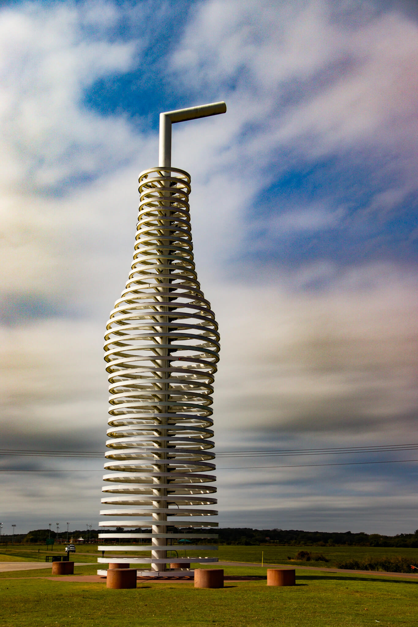
Pop into Pops for a soda experience like no other.
I found a much newer attraction on Route 66, also in Arcadia, just a few minutes away. Pops 66, a roadside hybrid gas station–diner–soda shop, opened only in 2007. You can’t miss it: An extremely tall (deliberately rising 66’) soda bottle, made with steel hoops (and complete with a straw) whose thousands of LED lenses are illuminated at night in rich neon colors, is an eye-catching and irresistible sight right along the road. A massive cantilever roof extends out over the gas pumps and entrance. Although all modern on the outside, the diner, with booths and counter service, feels like a 1950s hangout straight out of Grease or Happy Days, with burgers and shakes at the top of the menu. The big draw, however, is the soda shop. With 700 different sodas (or, in Midwestern American, pops) and drinks available for sale, I spent far too long browsing the shelves for something to satisfy my sweet tooth. Although I succumbed to giving myself a cavity with a couple of bottles—grape and lime—I had to assume that other flavors are geared toward the truly courageous or unabashedly curious: grass, bacon, peanut butter and jelly, kumquat, ranch dressing, sweet corn, and beef jerky.
A half hour later, I reached Oklahoma City. Realigned and rerouted several times in the city during the course of its history, Route 66 passes by some key attractions, the grandest of which is the Oklahoma State Capitol. Erected in 1917 with lots of Corinthian columns and 650 rooms, the capitol is the only one in the United States with working oil wells on its grounds. Its dome, which wasn’t fully finished until 2002, is topped by The Guardian, a three-ton, 17½’-tall bronze statue of an American Indian man with characteristics of all 39 tribes in Oklahoma.
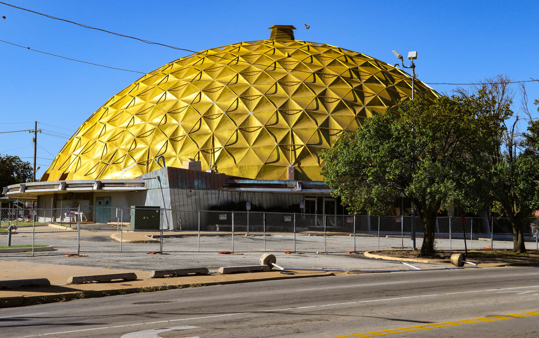
The Gold Dome Building has seen better days, but it may have a promising future.
Two of the city’s stranger Route 66 sites, unfortunately, remain shuttered. The first, the Citizens State Bank, better known as Gold Dome Building, looks like a shiny alien spacecraft straight out of a 1950s science fiction B-movie. The world’s fifth geodesic dome to ever be built—and the first bank in the world constructed in this style—bears 625 gold panels atop its short base and sports a diameter of 145’. After the bank closed, it remained abandoned for years and has clearly lost some of its luster. But salvation is near: Added to the National Register of Historic Places in 2002, Gold Dome has been purchased and is slated for renovation and repurposing, keeping the iconic dome intact.
Just a couple of blocks away, the isolated Milk Bottle Grocery sits on its own triangular island in the middle of a busy street. Like Gold Dome, this structure is also abandoned, despite being listed on the National Register of Historic Places in 1998. Built in 1930, the one-story brick wedge was known as the Triangle Grocery from 1940 to 1948, when the name changed with the addition of its defining characteristic—a giant milk bottle, as tall as the building itself, on its roof. An ice cream cone on a background of a blue “B” is painted on two sides of the white bottle, with “Braum’s” (a well-known Oklahoma-based dairy) below it and the company’s slogan, “Oklahoma’s Milk,” above. The bottle was added to the newly christened Milk Bottle Grocery to attract the attention of drivers along Route 66 as well as to advertise the state’s dairy industry.
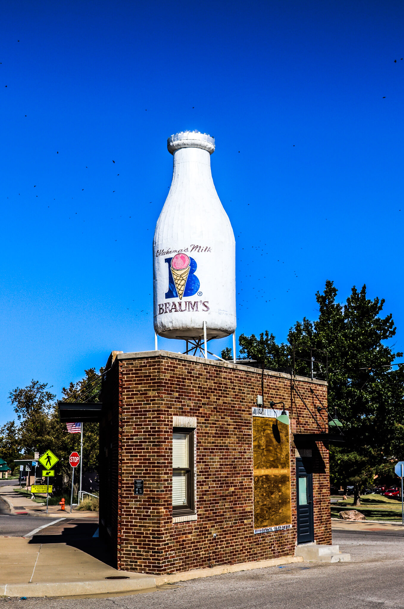
A bottle as tall as a building in Oklahoma City.
Now that I had seen a fine sampling of Route 66’s eccentric appeal, I wanted to put it all into context, so I headed an hour west on Interstate 40 (one of Route 66’s killers) to Clinton to visit the state’s defining showcase of the road. The Oklahoma Route 66 Museum documents everything about the famous road, starting with outdoor exhibits that include an orange Dodge gas truck for Phillips 66 and a Valentine Diner, a factory-built diner that could be found all along Route 66 starting in 1938. Built by the Valentine Manufacturing Company up until 1974, these small, boxy diners could accommodate no more than 10 customers sitting around an L-shaped counter and did not contain any tables or booths. Owners had to fork over $5,000 to buy a diner and open their business, and they paid for it by placing 10% of their daily gross income in a lock box at the front entrance to be collected by a Valentine representative every month.
Inside the museum, artifacts, relics, signs, and photographs fill the chronologically ordered rooms, from the route’s origins in the 1920s, when rough, unpaved roads posed some serious automotive challenges to the Model Ts bouncing along on it, to its role as escape route for desperate Dust Bowl victims heading to the promised land of California. Its rising popularity was accompanied by astounding development, from the rise of new towns and cities to the creation of two defining moments in the history of the automotive industry—one good, one bad. The first was dedicated gas stations that obviated the need of drivers to purchase their fuel, in buckets, from liveries, repair shops, and general stores, and then funnel it into their tanks. With smaller tanks on these early cars, refueling stops had to be made approximately every 70 miles, helping explain why the number of gas stations in the United States skyrocketed from 15,000 in 1920 to 124,000 only 10 years later. The second still exists as the bane of every driver: the world’s first parking meter, installed in Oklahoma City in 1935.
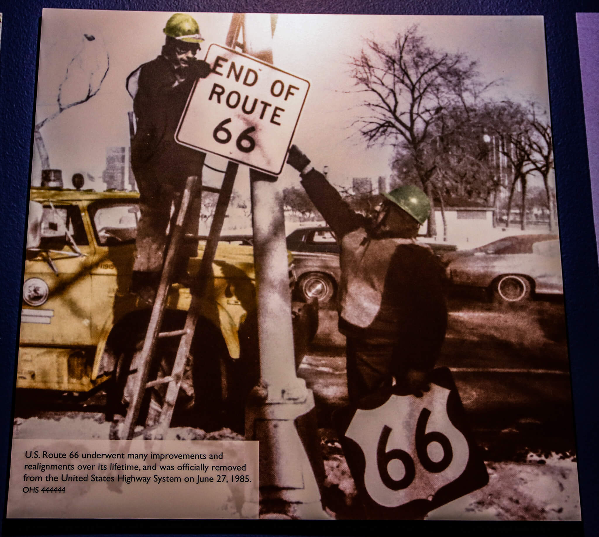
Route 66 may have officially ended in 1985, but renewed interest has resurrected it.
As Route 66 morphed into a leisure ride for newly affluent Americans in the 1950s, bizarre attractions like the ones I had seen (and others I hadn’t, like fake dinosaur parks and live rattlesnake shows) sprung up from the Windy City to the West Coast. Themed motels, with those diamond-shaped plastic key chains that I remember from my early youth, offered travelers overnight respite at affordable prices at regular intervals. In one of the galleries, a recreated diner invites you to sit in a vinyl booth, listen to music of the 1950s on the jukebox, and perch on a stool at the counter and imagine a waitress inevitably named Dot or Millie serving you a hot dog, some cheese fries, and a strawberry milkshake. The rise of Eisenhower’s interstate system ushered in the demise of Route 66, with the newer, faster highways bypassing small towns that relied on the route for their very existence. Devoid of travelers passing by, motels closed, diners went belly up, and gas stations emptied out. And when California, Illinois, and Missouri removed the 66 shields from the road in 1976, the “Mother Road” ceased to exist as a continuous stretch of highway, ending a unique era of social and cultural changes in America. Not long after the highway was officially decommissioned in 1985, myriad members of the public, private organizations, and government agencies who understood the historic and social significance of Route 66 began to clamor for its preservation and commemoration. Ultimately, the National Park Service Route 66 Corridor Preservation Program was created, providing financial and technical assistance to individuals, nonprofits, and government and tribal agencies, among others, to preserve significant places along the route.
With a resurgence of interest in Route 66 and nostalgic yearnings for road tripping on this iconic artery, travel associations have stepped up to promote travel to and along this celebrated road. “Historic Route 66” signs have been added to its old route, and some states have designated Route 66 as a State or a National Scenic Byway. Businesses along this iconic artery have re-emerged from an extended dormancy to accommodate travelers who are now cruising its length either for the first time, or those who are revisiting a trip from decades ago. Either way, you’ll be happy to, in the words of songwriter Bobby Troup, “get hip to this timely tip” and “take the highway that’s the best” when you “get your kicks on Route 66.”

